 | ICC 2537 |
|
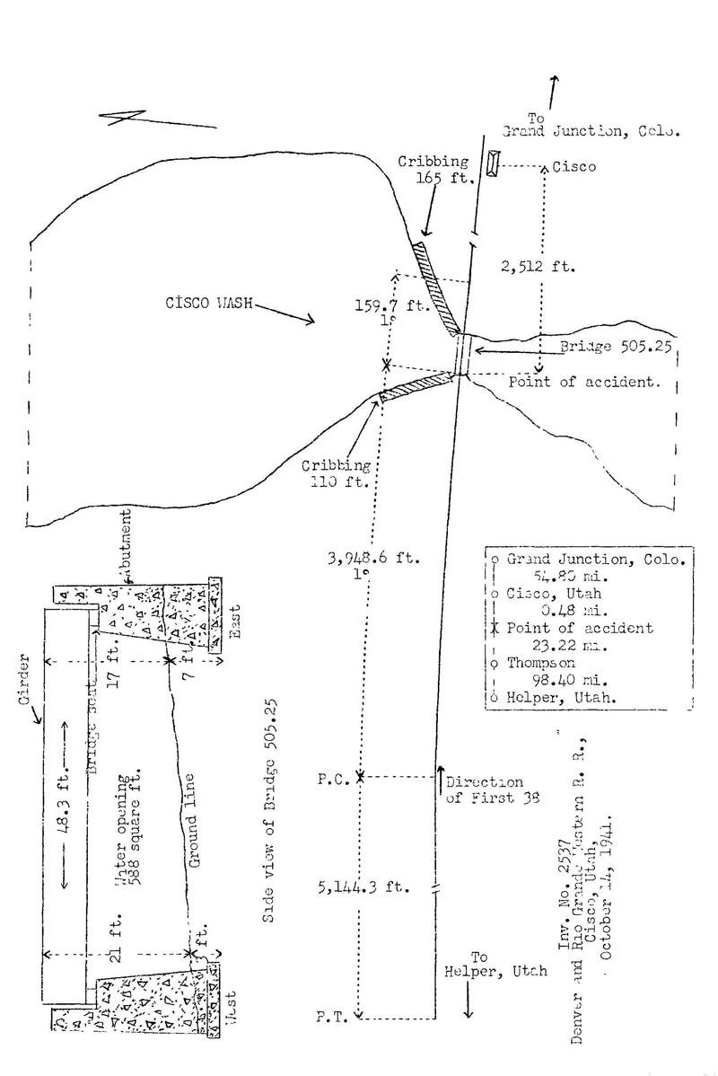
File Number 2537 Railroad DENVER & RIO GRANDE WESTERN RAILROAD Date 10/14/1941 Location CISCO, UTAH Accident Type D. INTERSTATE COMMERCE COMMISSION INVESTIGATION NO. 2537 IN THE MATTER OF MAKING ACCIDENT INVESTIGATION REPORTS UNDER THE ACCIDENT REPORTS ACT OF MY 6, 1910. THE DENVER AND RIO GRANDE WESTERN RAILROAD COMPANY December 15, 1941 Accident near Cisco, Utah, on October 14, 1941, caused by collapse of a bridge which had been weakened by flood water. REPORT OF THE COMMISSION 1 PATTERSON, Commissioner: On October 14, 1941, there was a derailment of a freight train on the Denver and Rio Grande Western Railroad near Cisco, Utah, which resulted in the death of one employee and the injury of two employees. Diagram Inv. No. 2537 Denver and Rio Grande Western R.R., Cisco, Utah, October 14, 1941. Location of Accident and Method 9f Operation This accident occurred on that part of the Grand Junction Division designated as Sub-Division 5, which extends between Helper, Utah, and Grand Junction, Cob., a distance of 176.9 miles. In the vicinity of the point of accident this is a single-track line over which trains are operated by timetable, train orders and an automatic block-signal system. The accident occurred at Bridge 505.25, which spans Cisco Wash at a point 2,512 feet west of the station at Cisco. At this bridge the stream flows from north to south. As the point of accident is approached from the west there is a tangent 5,144.3 feet in length, which is followed by a 1 degrees curve to the right 3,948.6 feet to the point of accident end 159.7 feet beyond. At the point of accident the grade for east-bound trains is 0.17 percent ascending. The track structure immediately west of Bridge 505.25 consists of 112-pound rail, 39 feet in length, laid on 24 treated ties to the rail length; it is single-spiked, fully tieplated with double-shoulder tieplates, laid on 14 inches of gravel and slag, and is well maintained. Bridge 505.25, a ballast-deck bridge constructed in 1901 to replace a pile and timber trestle, was a single-track deck-plate girder structure 48 feet 3 inches long. This structure was supported by two monolithic concrete abutments without reinforcement. The west abutment was 21 feet 3 inches high and 13 feet 10 inches wide. A bridge seat at the top of the abutment and on the stream side measured 3 feet 1-1/2 inches longitudinally and 4 feet 9-7/8 inches vertically. This abutment was 7 feet 8-1/2 inches thick at the bottom and 5 feet 7-1/2 inches thick at the bottom of the bridge seat. The abutment had two 20-foot concrete wings 2 feet thick, which were at 45-degree angles to the face of the abutment. The abutment and the wings were supported by a footing 53 feet 10 inches long, 2 feet thick, and from 7 feet 5 inches to 9 feet 8-1/2 inches wide. The footing was set on clay and shale and its top was about 3 feet below the ground line. The abutment, wings and footing contained about 184 cubic yards of concrete. The east abutment was similar in construction to the west abutment, except that the downstream wing was in line with the face of the abutment. The top of the footing of the east abutment was about 7 feet below the ground line. The girder span was constructed of web plates 59-3/4 inches wide and 3/8-inch thick, with full-length 14-inch by 7/16-inch cover plates at top and bottom. These cover plates were reinforced by two 14-inch by 7/16-inch cover plates, one of which was 36 feet 7 inches and the other 27 feet 8 inches in length. Flange angles were 6-inch by 6-inch by 9/16-inch "L" sections, and stiffener angles were provided at approximately 5-foot intervals. The girder span was braced with four 3-inch by 3-1/2-inch by 3/8-inch angle cross frames. The top lateral-bracing consisted of two 3-1/2 inch by 3-inch by 3/8-inch angles connected to alternate stiffeners. The bottom lateral-bracing consisted of 3-l/2 inch by 3-inch by 3/8 inch angles. The girder rested on masonry plates 1. foot 11 inches square and 7/8 inch thick. The center-to-center bearing was 46 feet 5 inches. The ballast deck consisted of treated 6-inch by 8-inch timbers laid solidly. At the edges of the deck 6-inch by 8-inch wooden guard rails were provided to retain the ballast. The deck was covered with ballast to a depth of about 6 inches. On the bridge the track structure was similar to that west of the bridge. The bridge was designed for Cooper's E-50 loading. The abutments were riprapped when the bridge was built and in 1927 about 8 carloads of stone was placed at the upstream portion of the east abutment. A rock-filled timber crib about 6 feet high and about 110 feet long extended northward at an angle of about 80 degrees to the track, from the north end of the upstream wing of the west abutment. A similar crib 165 feet long extended northeastward at an angle of about 25 degrees to the track, from the north end of the upstream wing of the east abutment. The rail was 21 feet above the ground line at the west end of the bridge and 17 feet above the ground line at the east end. The bottom of the girder was about 16 feet above the ground line at the west end and about 12 feet at the east end. Throughout a distance of approximately 700 feet immediately west of the bridge, the track was laid on a fill 5 or 6 feet high. Operating rules provide in part as follows: 825. in case of an extraordinary rain storm or high water, train must be brought to a stop and a man sent out to examine bridges, * * *, before passing over. In the vicinity of the point of accident the maximum authorized speed for freight trains is 45 miles per hour. Description of Accident First 38, symbol SPF-115, an east-bound second-class, freight train, consisted of engine 1601, 36 loaded and 4 empty cars and a caboose. After a terminal air-brake test was made this train departed from Helper, Utah, 122.1 miles west of Cisco, at 10:30 p.m., October 13, according to the dispatcher's record of movement of trains, 3 hours 5 minutes late, departed from Thompson, 23.6 miles west of Cisco and the last open office, at 5:16 a.m., 6 hours 24 minutes late, and while moving at a speed estimated at 45 miles per hour was derailed at Bridge 505.25. Engine 1601 was derailed and stopped on its right side, badly damaged, parallel to the track and about 8 feet south of it, with the front end of the engine 205 feet east of the west abutment. The tender was derailed, stopped in the channel near the east abutment and was demolished, The first to the twenty-sixth cars, inclusive, were derailed and stopped in the channel at various angles to the line of Crack. These cars were practically demolished and three of them were washed downstream distances of 236 feet, 389 feet and 620 feet south of the bridge. The brakes of First 38 had functioned properly en route. After the accident the girder span was found in the channel, with the east end near the east abutment and the west end about 35 feet south of the west abutment. The west abutment was shifted eastward about 10 feet and it inclined eastward. The east abutment was moved eastward about 1 foot and was broken into several pieces as a result of being struck by derailed cars. The channel was blocked by derailed cars. The fill was washed out a distance of 66 feet immediately west of the west abutment and a distance of 38 feet immediately east of the east abutment. A section of cribbing 30 feet long and directly north of the west abutment was washed out. The footing of the west abutment had been scoured and the washout reached a depth of 24 feet below the top of the rail throughout a distance of 30 feet immediately west of the west abutment. It was dark and the weather was cloudy at the time of the accident, which occurred at 5:49 a.m. The employee killed was the engineer and the employees injured were the fireman and the front brakeman. Data The watershed drained by Cisco Wash contains approximately 93 square miles. The earth in this watershed is of such nature that it will absorb but little water. Throughout a distance of 5 or 6 miles immediately north of the bridge, the grade of the channel averages about 2-1/2 percent descending southward. Most of the time the channel is dry. At a point 200 feet north of the bridge involved, the high-water level indicated that the cross-sectional area of the water was 2,511 square feet. It is probable the height of the water was increased as a result of the channel being dammed by derailed cars. The cross-sectional area of the space between the abutment and below the girder was about 588 square feet. At a point 290 feet south of the bridge, the cross-sectional area of the water at its peak was 914 square feet. Discussion First 38 was moving on a 1 degrees curve to the right at approximately 45 miles per hour, the maximum speed authorized for this train at this location. As the engine entered upon the bridge involved it seemed to drop about 2 feet and then it dived abruptly and stopped on the roadbed, in line with the track with its front end about 150 feet east of the east abutment. The tender and 26 cars dropped into the channel. Three of these cars floated downstream and the remainder blocked the channel. There was no defective condition of the engine that might have contributed to the derailment. The track west of the point of derailment was in good condition. The fireman, who was on the outside of the curve, did not observe any unsafe condition of track prior to the time of the derailment. It is not known if the engineer saw any abnormal condition before the derailment occurred, as he was killed in the accident; however, since he took no action to stop the train, it is probable he did not see the defective condition. It is probable that the west abutment had been displaced and the adjacent fill weakened in such manner that the impact of the engine on the bridge caused the girder to become displaced from its normal location. During the 24 hours preceding the time of accident, considerable rain had fallen in the vicinity of the point of accident. When the track was patrolled about 7 hours prior to the time of the accident, about 2 feet of water was flowing beneath the bridge. The crew of an east-bound train which passed over the bridge involved 14 minutes before the accident occurred did not observe unusually high water or any defect in the bridge. As a result of the accident the channel was obstructed end the water dammed by derailed cars and it was not possible to determine the exact height of the stream at the time of accident; however, a highway bridge over this stream, located 1,300 feet south of the point o accident, was not damaged except for slight cutting of a fill at the east end of this bridge. The channel clearance of this bridge was relatively large. After the accident occurred a considerable amount of the fill at each end of the railroad bridge was washed out The manner in which the cribbing north of the west abutment and the fill immediately west of the west abutment were washed out and the footing was scoured indicated that the water was flowing rapidly. The grade of the channel for several miles north of the bridge averaged 2-1/2 percent descending. There were indications that the current changed from its normal course and flowed directly toward the west abutment instead of midway between the two abutments. In 1927 a small portion of the fill immediately east of the east abutment was washed out but the west abutment and the fill west of the west abutment had not been damaged prior to the time of the accident here under discussion. Cause It is found that this accident was caused by the collapse of a bridge which had been weakened by flood water. Dated at Washington, D. C., this fifteenth day of December, 1941. By the Commission, Commissioner Patterson. W. P. BARTEL, (SEAL) Secretary. FOOTNOTE: 1 Under authority of section 17 (2) of the Interstate Commerce Act the above-entitled proceeding was referred by the Commission to Commissioner Patterson for consideration and disposition. |
||||||||||||||||||||||||||||||||||||||||||||||||||
|
Questions/corrections/comments welcome - email me Please see our disclaimer. |
Last modified on February 22, 2006, at 02:14 PM Edit Page | Page History |